
Ester Dome
SE quad of Ester Dome
??
Grant Mine Project APMA# F20237130 (2023 Application for Permits to Mine in Alaska - project 7130)
COMMENTS WERE DUE MONDAY, MAY 8. The decision is pending and may be DELAYED because there is an old impoundment pond from when Grant Mine was active in the 1980s that needs to be closed before the APMA is approved but the closure has faltered. ('APMA 7130' includes both final remediation of the contaminated site and the drilling and trenching plan for the ridge above the contaminated site.)
Questions concerning APMA F20237130 (sometimes 237130, or project 7130) and requests to view the full application packet should be directed to Jadon Farleigh, Telephone (907) 458-6885; Fax: (907) 451- 2703 or e-mail: dnr.fbx.mining@alaska.gov.
Opposition to this mine and your concerns about quality of life are important!!
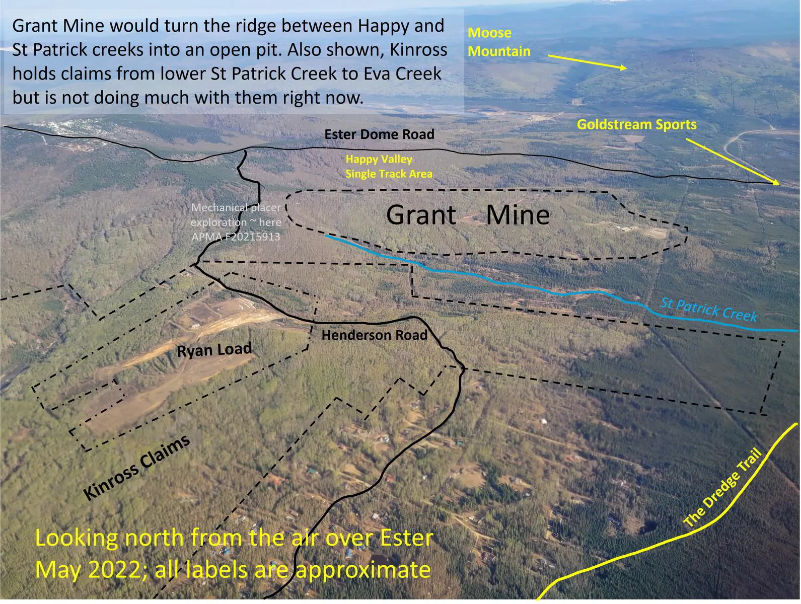
It's "just exploration" but the point is to build a mine, which is completely incompatible with residential and recreational uses that have grown in the area over 30 years of mine dormancy. If Grant Mine is developed, Felix Gold will take millions of tons of rock out of an open pit on the ridge between Happy Creek and St Patrick's Creek, which it describes here:
How would development of this mine impact you? Consider offering a personal take on how a mine here would affect your property values, resale values, quality of life, recreational opportunities, and access to hunting, trapping, wild foods, and forest products.
Alaska Mapper: All Status “ArcGIS USA Topo Map” base map with “Recreation Land” as the only selected layer with an overlay of crowdsourced trails from Strava and a circle around the Grant Mine proposed initial drilling and trenching area.
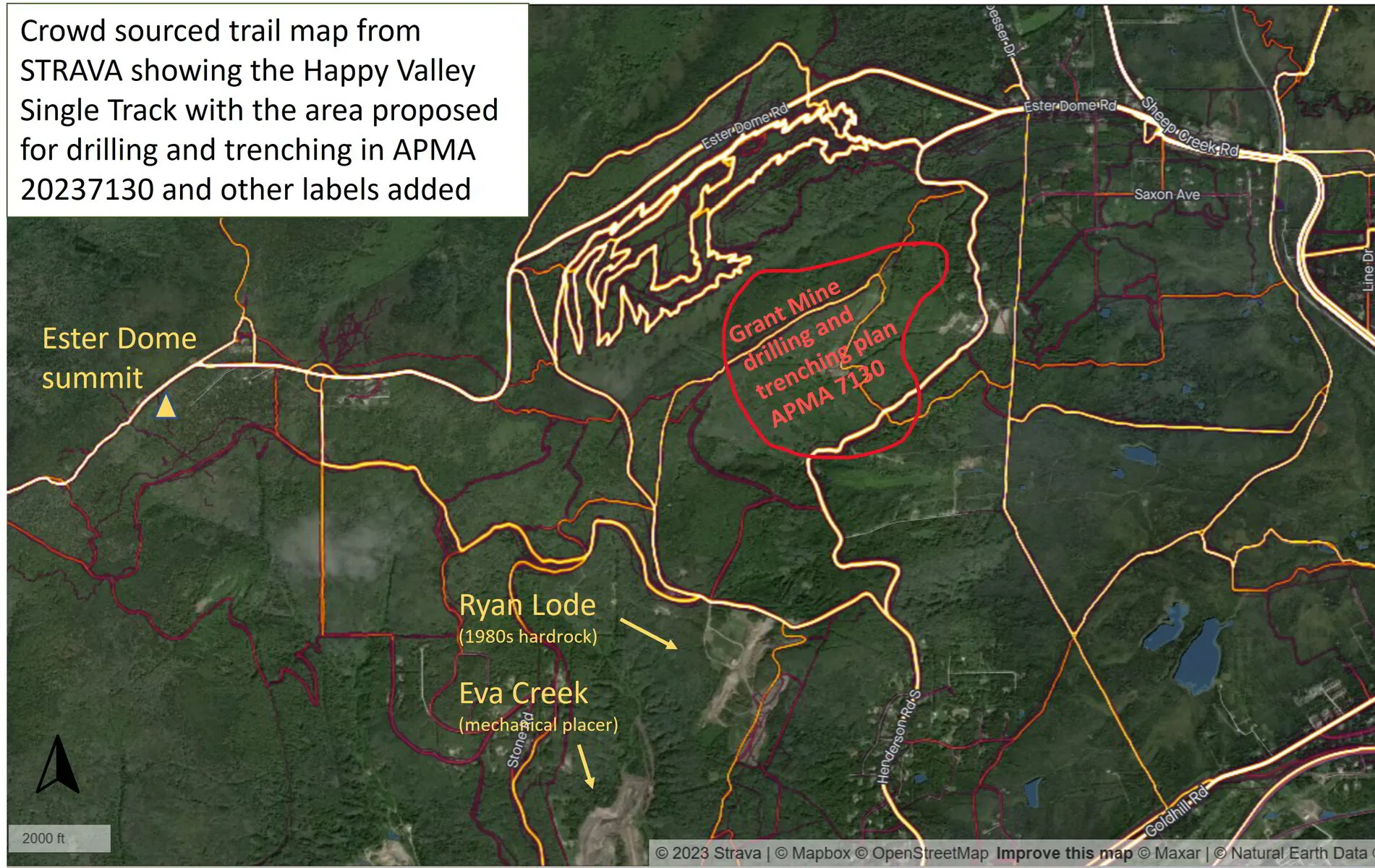
The brightest lines are most traveled: Ester Dome Road (west-east) the Happy Valley Single Track, and St Patrick’s Road running thru the project area (north-south).
WATCH FOR MORE CHANGES TO THE BROADER ESTER DOME PROJECT
APMA# F20212139 (link to the Application for Permits to Mine in Alaska)
Ester Dome is mostly designated as recreation land, but not exclusively! Grant Mine is on the east side, and then there is Nugget Creek, on the north side - complete with an RS2477 trail up to the top, around, and back down to Goldstream, as shown in the image below. These claims have been dormant but are already permitted for exploration and we are watching for proposals to drill.
Millrock withdrew applications for mining on Mental Health Trust lands because of local opposition, but consolidated exploration permits for most of the dome shown below in solid blue. "The Ester Dome Project area is composed of 60 State of Alaska Mining Claims and 94 claims under exploration agreements with second parties. In total there are 3,662 hectares of mineral rights controlled by Felix Gold and subject to Millrock royalty rights." (Source: https://www.millrockresources.com/projects/alaska/ester-dome)